Better Horse Farm Planning, Design and Visualization Through Drone Imagery
- Clay Nelson

- Oct 25, 2024
- 2 min read
Updated: Oct 25, 2024
Introduction
At Sustainable Stables, we strive to continually improve our equestrian property planning and design services. One way we accomplish this goal is by incorporating the latest technology into our services. A recent focus has been on advancing our ability to collect and use drone imagery to obtain higher-resolution geo-spatial data, allowing for improved and more cost-effective planning, design and visualization for horse farms and ranches.
A recent example: Mapping a large-acreage horse property in Texas
We recently mapped a 142-acre section of a client’s horse property using a DJI Mavic 3 drone. The drone captured 595 photos across the area mapped (shown in the image below). Flight time for this mapping took about 15 minutes.

Images were then processed through advanced drone mapping software, generating both 2D and 3D “orthomosaic” maps by stitching together the 595 images taken by the drone while correcting for factors such as flight altitude, camera lens distortion, and camera tilt.


Benefits of drones for horse farm planning
A drone’s ability to quickly analyze the land from various angles and perspectives allow us to capture ultra-high-resolution aerial imagery, revealing the intricate details of our clients’ landscape with greater clarity than can be provided using online maps like Google Earth.
This imagery allows us to…
Visualize the property in ultra-high-resolution 2D and 3D space
Generate contour maps that, under the right conditions, are accurate to within inches
Better identify the location of important landscape features, assess water drainage across the landscape, and inform earth-work and grading for equestrian improvements (barns, arenas, outbuildings, etc) with greater accuracy
Generate maps that represent current conditions, not those the last time a google satellite flew over the property (especially valuable for horse properties where recent clearing or grading work has been performed).


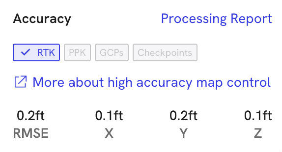
The image processing software can be used to create topographic maps with incredible accuracy. In this example, topographic accuracy is reported as 0.1 ft , 0.2 ft and 0.1 ft in the X, Y and Z axis respectively. Impressive for a 142-acre area mapped in approximately 15 minutes!
Conclusion: Drones = better planning, design and visualization of horse properties
Ultimately, better data means better planning and design of horse properties and equine facilities. Integrating drone data into our modeling and rendering software also allows us to create more accurate and realistic visualizations of what our clients' property will ultimately look like when our site plans and barn designs are brought to life.
To learn more about our equestrian property planning and design services, please visit https://www.sustainablestables.com/services.


Comments